Fort Stage Ride (FSR)
A low-carbon cross-country mountain biking adventure validating climate action, living history, and rugged terrain across Nepal’s Bagmati Province.
The Fort Stage Ride 2026 Trailer
What is Fort Stage Ride?
The Fort Stage Ride (FSR) is Nepal’s premier cross-country mountain biking (MTB XC) event and validation corridor, designed to challenge riders while immersing them in the deep heritage and dramatic terrain of Nepal’s Bagmati Province.
Inspired by the historical “Strategic Triangle” of Hariharpurgadhi, Sindhuligadhi, and Makwanpurgadhi, this ride combines high-endurance athleticism, living history, and the rugged beauty of Nepal’s mid-hills.
Context & Regional Diversity
Bagmati Province stretches from high Himalayan peaks down through the mid-hills to the fertile Inner Terai, creating a region rich in religious, cultural, and geographic diversity.
While blessed with immense tourism potential, many of its historic fort settlements, sacred temples, and indigenous ecological zones remain vulnerable due to a historical lack of promotion, preservation, and accessible information. The Fort Stage Ride directly revitalizes these forgotten corridors.
Photo Gallery

Why Join?
An impact-driven cross-country structure backed by climate science and community equity.
Explore Forgotten Frontiers
Redefine adventure by mapping Nepal’s historic mid-hill defense corridors on two wheels.
Validate True Climate Action
Support a ride backed by real science, tracking Scope 1, 2, and 3 emissions under IPCC 2006/2019 guidelines.
The 80/20 Economic Model
Ensure your journey counts. 78.5% of your travel expenditure is retained directly within local households and women-led cooperatives.
Immerse in Indigenous Resilience
Experience authentic hospitality by staying directly with Tamang, Newar, Hayu, and Magar host communities.
Zero Food Miles Architecture
The 10-KM Plate
Riders will stay in living cultural villages where hospitality is circular. In compliance with local homestay regulations, 80% of all food ingredients are organic and sourced within a 10km radius of your host village, completely erasing agricultural “food miles”.
The Route
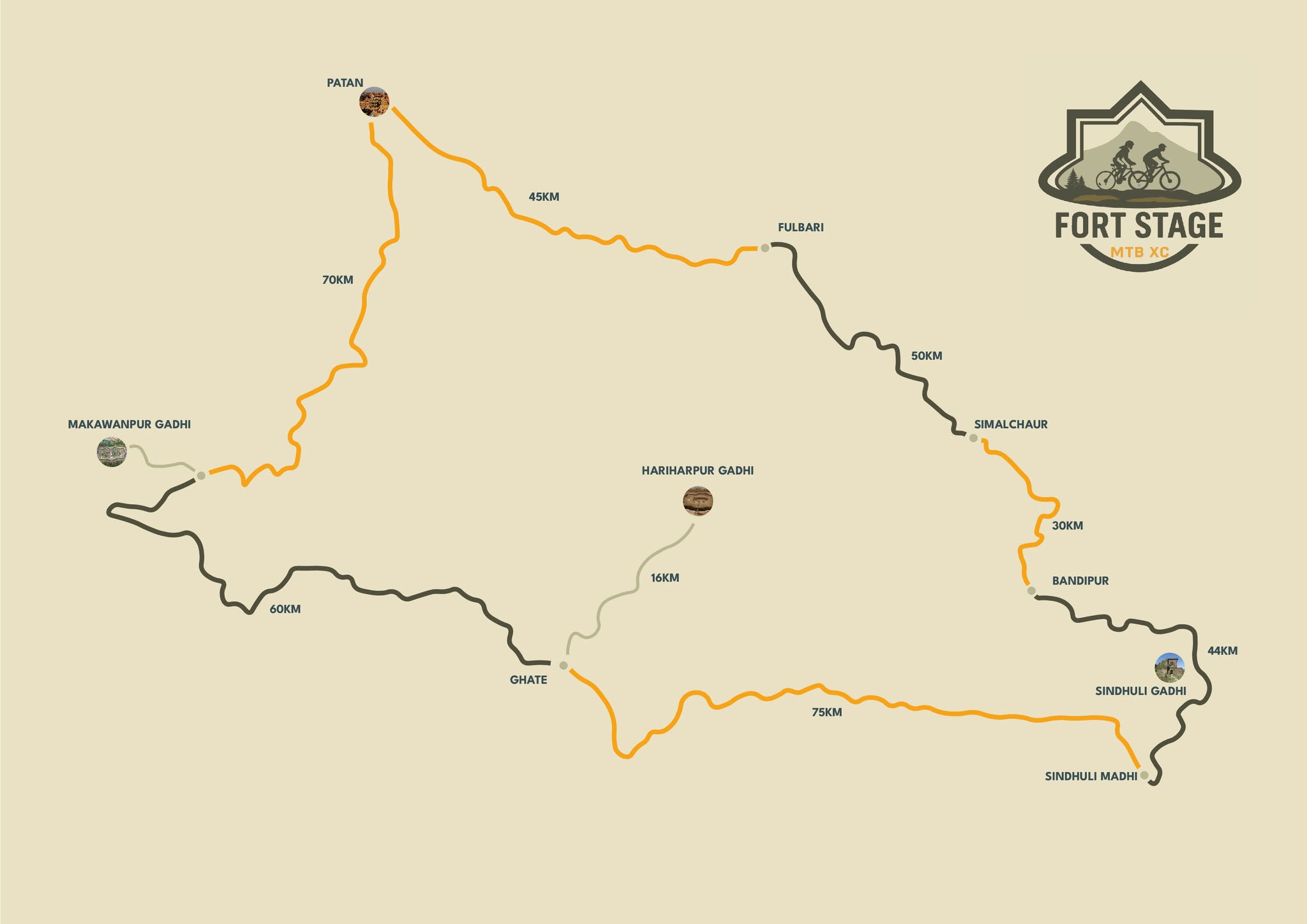
The Fort Stage Ride is a verified 390.5-kilometer circular route that begins and ends at the StoryCycle Hub in Patan (Kani Bahal / Mangalbazar). This trail loops through 14 strategic community nodes, connecting three historic defense forts—Hariharpurgadhi, Sindhuligadhi, and Makwanpurgadhi.
25% Asphalt | 20% Single-Track
◆ 20% Black
Chronological Stage Breakdown
Follow the multi-day expedition corridor stage by stage.
Day 1
Lalitpur Ward 6 Panauti – Phulbari
⛰️ 1300m – 1535m
25% Asphalt / 75% Paved
Panauti Market / Heritage Taps
Easy urban exit leading into steep Lakuri Bhanjyang climb. Descend to ancient Panauti.
Day 2
Phulbari – Baluwatar – Hayu Village
⛰️ 1535m – 581m
Steep Gravel & Dirt
Baluwatar Market / Spring Points
Long descent to Sunkoshi river. Low-altitude transition with sharp climb to Hayu node.
Day 3
Hayu Village – Bhorleni Kotgaon
⛰️ 600m – 900m
Dirt & Technical Tracks
Bhorleni Riverside / Local Taps
High-gradient riverine navigation. Challenging, unpaved single-track climb.
Day 4
Kotgaon – Sindhuligadhi Sindhuli Madhi
⛰️ 900m – 1400m
Mixed Gravel & Asphalt
Sindhuli Madhi Hub / Stone Taps
Historical fort audit. Traverse Bandipur and Nagi ridges prior to long asphalt descent.
Day 5
Sindhuli Madhi Marin Valley Hariharpurgadhi
⛰️ 600m – 1100m
Paved & Dirt Tracks
Marin Agricultural Hub / Wells
Flat speed section in valley. Transition to technical dirt climb up to the historic fort.
Day 6
Hariharpurgadhi – Hatti Sude Makwanpurgadhi
⛰️ 1100m – 1200m
100% Technical Single-track
Hatti Sude / Piped Mountain Springs
High technicality through heritage woods. Final steep trail climb to the anchor fort.
Day 7
Makwanpurgadhi – Thingan Pass – Patan Return
⛰️ 1200m – 1600m
Gravel & Asphalt Mix
Thingan Hub / River & Tap Networks
Frontier climb to Nagi Ridge. Continuous technical descent back to the urban rim.
Who Should Apply?
Luxury is stripped away to make room for pure, raw backcountry connection.
Passionate Mountain Bikers
Cyclists looking to test their limits on terrain ranging from fast valley flats to technical, high-gradient fort rampart climbs.
Endurance-Ready Athletes
Individuals who are physically fit, self-reliant, and thoroughly experienced with multi-day backcountry rides.
Impact-Driven Explorers
Advocates interested in eco-tourism, indigenous knowledge systems, historical preservation, and active climate adaptation.
True Adventurers
Riders ready for a self-managed, highly coordinated expedition focused on raw connection with the community.
What to Bring
1. The Machine & Safety Gear
- Mountain Bike (Cross-Country/XC hardtail or short-travel full suspension preferred).
- Certified helmet, protective eyewear, and high-visibility cycling gear.
- Comprehensive multi-tool and basic trail repair kit (spare tubes, pump, chain breaker, patch kit).
2. The Zero-Waste Eco-Kit
- High-capacity refillable water bottles or hydration packs.
- Personal Eco-Kit: Strict zero single-use plastic policy along the entire corridor.
- Bring reusable containers and utensils.
3. Apparel & Trail Nutrition
- Multi-layered clothing tailored for rapid temperature shifts between river basins (324m) and ridge passes (1600m).
- Energy bars and personalized trail snacks.
- Personal Wilderness First Aid (WFA) pocket kit.
Join the Route
Registration is officially open for the December 2026 corridor cycle. Spaces are limited to preserve structural regional eco-footprints.